Boxed Style

আইফোন জিতে ক্লিক করুন

Monday 29 April 2013

ক্ষমা করো জয়ন্ত ভাই হতে পাড়িনি


বুধবার অফিসিয়াল কোন অ্যাসাইনমেন্ট নেই। তাই কর্মকর্তাদের সঙ্গে গল্প করে নিউজ তুলে আনতে গেলাম কারওয়ান বাজারের একটি অফিসে। হঠাত করেই ফোন পেয়ে মোটরসাইকেল নিয়ে মাত্র ২৫ মিটিটে চলে গেলাম সাভার। তখনো রানা প্লাজার অবস্থান সম্পর্কে আমার স্পষ্ট ধারনা নেই। সাভার উপজেলা পরিষদের  সামনে যাওয়ার পর লাঠি হাতে এক শিশু, দুই যুবক আর এক বৃদ্ধ এসে আমার গতি রোধ করে বললো যাওয়া যাবে না। আমি সাংবাদিক পরিচয় দেওয়ার পার ষাটউর্ধ্ব বৃদ্ধ লোকটি ঠোঁট থেকে বাঁশি ছেড়ে দিয়ে আমার পিঠে হাত বুলিয়ে বললেন বাবা আপানে একটু এনাম মেডিকেলের সামনে দিয়া ঘুইরা যান। সে পথ বলে দিলো। কিন্তু এনাম মেডিকেলের সামনের রাস্তায় মোটরসাইকেল নিয়ে প্রবেশ করার পর ভয়াবহতার কিছুটা আচ্ করতে পারলাম। ঢাকা-আরিচা মহাসড়কের পাশে রানা প্লাজার সামনে যখন পৌঁছালাম তখন শুধু শত শত নারী পুরুষের কান্না আর হাজার হাজার মানুষের ভীড় ঢেলে চোখে পরলে অ্যাম্বুলেন্সের আসা যাওয়ার দৃশ্য। রাস্তায় হাজার হাজার মানুষের মধ্যে যেন সুপারসনিক গতিতে ছুলে চলেছে অ্যাম্বুলেন্সগুলো। এলজিআরডি প্রতিমন্ত্রী জাহাঙ্গীর কবির নানক একটি চ্যানেলের সরাসরি সম্প্রচারে রক্তের জন্য আবেদন জানাচ্ছেন। হঠাত একটি অ্যাম্বুলেন্স মন্ত্রী পাশে সরে গেলেন। এরপর নিজেই উতসুক জনতাকে সরি দিয়ে রাস্তা পরিস্কার করে দিলেন। বেলা একটায় আমার এক সহকর্মীর নির্দেশে আমি চলে গেলাম এনাম মেডিকেল কলেজে। সেখানে অ্যাম্বুলেন্স আর ট্রলির আসা যাওয়ায় ভিতরে প্রবেশ করাই কষ্ট কর। তবুও এক ফাঁকে ঢুকে পড়লাম। কোথায় কথা বলবো? কে জানাবেন তথ্য? শত শত রোগী, শত শত ডাক্তার। মনে প্রশু জাগলো, এত ডাক্তার এলো কোথেকে। খুঁজে খুঁজে জনসংযোগ কর্মকর্তার কটি আবিস্কার করলাম নিচতলায়। তবে সেখানে প্রবেশ করবে  কি করে? সামনে অর্ধশত রোগী। কারোর মাথা থেকে রক্ত ঝড়ছে, কারোর ঠোট, মুখ বিকৃত, কারোর হাত, পা নড়ছে না। প্রায় আধা ঘন্টা এমন দৃশ্য দেখে প্রবেশ করলাম কক্ষে। পরিচয় দিতেই জনসংযোগ কর্মকর্তা পরিচয় করিয়ে দিলেন তার সামনে দাঁড়িয়ে থাকা একজন মানুষের সঙ্গে। তিনিই জানালেন হাসপাতালের ওই দিনের চিত্র। রাস্তায় এপ্রোন গায়ে যারা ট্রলি টানছে তারাও ডাক্তার, মেডিকেলের শিক, ছাত্র। এনাম মেডিকেলের ডাক্তার, ছাত্র, শিক, নার্স কর্মকর্তা কর্মচারী সবার প্রতি নির্দেশনা ছিলো রানা প্লাজার রোগীদের দ্রুত চিকিতসা সেবা দেওয়ার। ৩৫ বেডের আইসিইউ, ২৫ বেড়ের সিসিইউ খালি করা হলো মহৃহহৃর্তে। বন্ধ করে দেওয়া হলো পূর্ব নির্ধারিত সকল অপারেশন। সেদিন সেখানে কে ডাক্তার, কে ছাত্র, কে শিক, কে নার্স, কে কর্মকর্তা তার চেয়ে বড় পরিচয় ছিলো ওরা সবাই মানুষ। তারা অক্লান্ত ভাবে ছুটছে মানুষের জন্য, মানুষের জীবন বাঁচাতে। ততক্ষনে হাসপাতালের পিছনের ওয়ার হাউজে জমেছে ৩৫টি লাশ, স্টম ওয়াশরুমে আছে আরো ১৪টি লাশ। জনসংযোগ কর্মকর্তা জাহিদুল রহমানের পরিচয় করিয়ে দেওয়া নির্দেশদাতা ওই ব্যক্তিরই ছিলেন হাসপাতালটির মালিক ডা.এনামুর রহমান। একজন ছুটে এসে বললো কে যেন একজন ওষধ পাঠাতে চায়। কিন্তু এনামুর রহমান জানালেন আগে তার স্টোরের সকল ওষধ শেষ করতে।
বিকেল যত গড়াতে থাকে দীর্ঘ হতে থাকে লাশের সাড়ি। আহত আর নিহতের ট্রলি গড়াচ্ছে একই দরজার চৌকাঠে। তাই ব্যহত হচ্ছে আহতের সেবা। পরে সিদ্ধান্ত হলে লাশ যাবে পার্শ্ববতী অধরচন্দ্র উচ্চ বিদ্যালয় মাঠে। এনাম থেকে বেড় হয়ে আশপাশে খোঁজ নিয়ে দেখা গেলো সাভারের ত্রিশটি হাসপাতাল ও কিনিকেই চলছে জরুরী চিকিতসা সেবা। স্বজনদের ভিড় যখন বাড়তে শুরু করলো তখন হাসপাতালগুলো দেওয়ালে সাটিয়ে দিলো ভর্তিকৃত আহদের নামের তালিকা। কিন্তু নিহতদের তালিকা করবে কে। অধরচন্দ্রের বিশাল মাঠে হাজার হাজার স্বজনের আর্তনাদ। মাঠের মাঝে পুলিশের পক্ষ থেকে একটি বুথ ঘোলা হয়েছে। স্কুলের ক্যান্টিনে বসেছেন জেলা প্রশাসকের লোকজন। অধরচন্দ্রের দীর্ঘ বারান্দ ভরে গেলো সারি সারি লাশে। একনজর লাশের মুখ দেখে স্বজনরা চিহ্নিত করছেন লাশ। পরে পুলিশের খাতায় নাম লিখে টোকেন নিয়ে জেলা প্রশাসকের কাছ থেকে লাশ বহনের জন্য ২০ হাজার টাকা নিয়ে যাচ্ছেন স্বজনরা।
রাত সাড়ে নয়টা পর্যন্ত তিনটি নিউজ লিখে দুঘটনাস্থল ঘুরে রাত দেড়টায় সভার থানায় গেলাম দুটি গ্রেফতারের উড়ূ খবরের নিশ্চয়তা নিতে। তবে সেখানে গিয়ে ভবন মালিক রানার বাবা গ্রেফতারের উড়ূ খবরটির সঙ্গে জুটল পুলিশের আরো একটি উদাসীন খবর। এক কর্মকর্তা বাদি করলেন রানার বাবা মৃত। সাভার এলাকায় কর্মরত সমকালের নিজস্ব প্রতিবেদক নিশ্চিত সঙ্গে সঙ্গে তা চ্যালেঞ্জ করে ভুল প্রমান করলেন। এরপর আমরা তিনজন আর ছুটে এলাম বিদ্যালয় মাঠে। এবার সারাদিনের অদম্যতা আর কঠোর মন গলে গেল একটি কান্নার শব্দে। শিশু যশোধার কান্নার শব্দে ছুটে গেলাম কাছে। তার ভাই জয়ন্ত মারা গেছে। স্বজনরা তখন লাশ গ্রহনের জন্য জেলা প্রশাসকের সামনের অপেমান। কিন্তু অন্য এক আত্মিয়ের কোলে যশোধার গগণবিদারী ভাই ভাই চিতকার আমাকে নাড়া দিলো। অজান্তেই নোনা জলের বাঁধ ভেঙ্গে গেল। লাশের সাড়ি দেখতে যাওয়া আতাউর ভাইকে ফোন করে গালি দিয়ে ডেকে এনে দ্রুত পালালাম অধরচন্দ্রের মাঠ থেকে।দ্বিতীয় শ্রেনীর ছাত্রী যশোধাকে ভাই হারানোর সান্তনা আমার জানা ছিলো না। মা করো জয়ন্ত। তোমার যশোধার ভাই হতে পারিনি। তোমার ভালোবাসায় ভাগ বসাতে পারিনি। 

Friday 19 April 2013

Huashan - The Most Dangerous Mountain Route in China

Huashan - The Most Dangerous Mountain Route in China

Mount Hua, or Hua Shan is a mountain located near the city of Huayin in Shaanxi province, about 120 kilometres (75 mi) east of Xi'an. It is one of China's Five Great Mountains, and has a long history of religious significance. Originally classified as having three peaks, in modern times the mountain is classified as five main peaks, of which the highest is the South Peak at 2,154.9 metres (7,070 ft).
Mount Hua is located near the southeast corner of the Ordos Loop section of the Yellow River basin, south of the Wei River valley, at the eastern end of the Qin Mountains, in southern Shaanxi province. It is part of the Qin Ling Mountain Range that divides not only northern and southern Shaanxi, but also China.
Mount Hua Shan is located near the southeast corner of the Ordos Loop section of the Yellow River basin, south of the Wei River valley, at the eastern end of the Qin Mountains, in southern Shaanxi province. It is part of the Qin Ling Mountain Range that divides not only northern and southern Shaanxi, but also China.

Mount Hua, or Hua Shan is a mountain located near the city of Huayin in Shaanxi province, about 120 kilometres (75 mi) east of Xi'an. It is one of China's Five Great Mountains, and has a long history of religious significance. Originally classified as having three peaks, in modern times the mountain is classified as five main peaks, of which the highest is the South Peak at 2,154.9 metres (7,070 ft).

As early as the 2nd century BCE, there was a Daoist temple known as the Shrine of the Western Peak located at its base. Daoists believed that in the mountain lives the god of the underworld. The temple at the foot of the mountain was often used for spirits mediums to contact the god and his underlings. Unlike Taishan, which became a popular place of pilgrimage, because of its inaccessibility to the summit, Huashan only received Imperial and local pilgrims, and was not well visited by pilgrims from the rest of China. Huashan was also an important place for immortality seekers, as many herbal Chinese medicines are grown and powerful drugs were reputed to be found there. Kou Qianzhi (365–448), the founder of the Northern Celestial Masters received revelations there, as did Chen Tuan (920–989), who spent the last part of his life in hermitage on the west peak. In the 1230s, all the temples on the mountain came under control of the Daoist Quanzhen School. In 1998, the management committee of Huashan agreed to turn over most of the mountain's temples to the China Daoist Association. This was done to help protect the environment, as the presence of taoists and nuns deters poachers and loggers. 26 more images after the break...

Mount Hua Shan is located near the southeast corner of the Ordos Loop section of the Yellow River basin, south of the Wei River valley, at the eastern end of the Qin Mountains, in southern Shaanxi province. It is part of the Qin Ling Mountain Range that divides not only northern and southern Shaanxi, but also China.

Mount Hua Shan is located near the southeast corner of the Ordos Loop section of the Yellow River basin, south of the Wei River valley, at the eastern end of the Qin Mountains, in southern Shaanxi province. It is part of the Qin Ling Mountain Range that divides not only northern and southern Shaanxi, but also China.

Mount Hua Shan is located near the southeast corner of the Ordos Loop section of the Yellow River basin, south of the Wei River valley, at the eastern end of the Qin Mountains, in southern Shaanxi province. It is part of the Qin Ling Mountain Range that divides not only northern and southern Shaanxi, but also China.

Mount Hua Shan is located near the southeast corner of the Ordos Loop section of the Yellow River basin, south of the Wei River valley, at the eastern end of the Qin Mountains, in southern Shaanxi province. It is part of the Qin Ling Mountain Range that divides not only northern and southern Shaanxi, but also China.

Mount Hua Shan is located near the southeast corner of the Ordos Loop section of the Yellow River basin, south of the Wei River valley, at the eastern end of the Qin Mountains, in southern Shaanxi province. It is part of the Qin Ling Mountain Range that divides not only northern and southern Shaanxi, but also China.

Mount Hua Shan is located near the southeast corner of the Ordos Loop section of the Yellow River basin, south of the Wei River valley, at the eastern end of the Qin Mountains, in southern Shaanxi province. It is part of the Qin Ling Mountain Range that divides not only northern and southern Shaanxi, but also China.

Mount Hua Shan is located near the southeast corner of the Ordos Loop section of the Yellow River basin, south of the Wei River valley, at the eastern end of the Qin Mountains, in southern Shaanxi province. It is part of the Qin Ling Mountain Range that divides not only northern and southern Shaanxi, but also China.

Mount Hua Shan is located near the southeast corner of the Ordos Loop section of the Yellow River basin, south of the Wei River valley, at the eastern end of the Qin Mountains, in southern Shaanxi province. It is part of the Qin Ling Mountain Range that divides not only northern and southern Shaanxi, but also China.

Mount Hua Shan is located near the southeast corner of the Ordos Loop section of the Yellow River basin, south of the Wei River valley, at the eastern end of the Qin Mountains, in southern Shaanxi province. It is part of the Qin Ling Mountain Range that divides not only northern and southern Shaanxi, but also China.

Mount Hua Shan is located near the southeast corner of the Ordos Loop section of the Yellow River basin, south of the Wei River valley, at the eastern end of the Qin Mountains, in southern Shaanxi province. It is part of the Qin Ling Mountain Range that divides not only northern and southern Shaanxi, but also China.


Temples  — Huashan has a variety of temples and other religious structures on its slopes and peaks. At the foot of the mountain is the Cloister of the Jade Spring , which is dedicated to Chen Tuan.


Mount Hua Shan is located near the southeast corner of the Ordos Loop section of the Yellow River basin, south of the Wei River valley, at the eastern end of the Qin Mountains, in southern Shaanxi province. It is part of the Qin Ling Mountain Range that divides not only northern and southern Shaanxi, but also China.

Mount Hua Shan is located near the southeast corner of the Ordos Loop section of the Yellow River basin, south of the Wei River valley, at the eastern end of the Qin Mountains, in southern Shaanxi province. It is part of the Qin Ling Mountain Range that divides not only northern and southern Shaanxi, but also China.

Mount Hua Shan is located near the southeast corner of the Ordos Loop section of the Yellow River basin, south of the Wei River valley, at the eastern end of the Qin Mountains, in southern Shaanxi province. It is part of the Qin Ling Mountain Range that divides not only northern and southern Shaanxi, but also China.

Mount Hua Shan is located near the southeast corner of the Ordos Loop section of the Yellow River basin, south of the Wei River valley, at the eastern end of the Qin Mountains, in southern Shaanxi province. It is part of the Qin Ling Mountain Range that divides not only northern and southern Shaanxi, but also China.

Mount Hua Shan is located near the southeast corner of the Ordos Loop section of the Yellow River basin, south of the Wei River valley, at the eastern end of the Qin Mountains, in southern Shaanxi province. It is part of the Qin Ling Mountain Range that divides not only northern and southern Shaanxi, but also China.

Mount Hua Shan is located near the southeast corner of the Ordos Loop section of the Yellow River basin, south of the Wei River valley, at the eastern end of the Qin Mountains, in southern Shaanxi province. It is part of the Qin Ling Mountain Range that divides not only northern and southern Shaanxi, but also China.

Mount Hua Shan is located near the southeast corner of the Ordos Loop section of the Yellow River basin, south of the Wei River valley, at the eastern end of the Qin Mountains, in southern Shaanxi province. It is part of the Qin Ling Mountain Range that divides not only northern and southern Shaanxi, but also China.

Mount Hua Shan is located near the southeast corner of the Ordos Loop section of the Yellow River basin, south of the Wei River valley, at the eastern end of the Qin Mountains, in southern Shaanxi province. It is part of the Qin Ling Mountain Range that divides not only northern and southern Shaanxi, but also China.

Mount Hua Shan is located near the southeast corner of the Ordos Loop section of the Yellow River basin, south of the Wei River valley, at the eastern end of the Qin Mountains, in southern Shaanxi province. It is part of the Qin Ling Mountain Range that divides not only northern and southern Shaanxi, but also China.

Mount Hua Shan is located near the southeast corner of the Ordos Loop section of the Yellow River basin, south of the Wei River valley, at the eastern end of the Qin Mountains, in southern Shaanxi province. It is part of the Qin Ling Mountain Range that divides not only northern and southern Shaanxi, but also China.

Mount Hua Shan is located near the southeast corner of the Ordos Loop section of the Yellow River basin, south of the Wei River valley, at the eastern end of the Qin Mountains, in southern Shaanxi province. It is part of the Qin Ling Mountain Range that divides not only northern and southern Shaanxi, but also China.

Mount Hua Shan is located near the southeast corner of the Ordos Loop section of the Yellow River basin, south of the Wei River valley, at the eastern end of the Qin Mountains, in southern Shaanxi province. It is part of the Qin Ling Mountain Range that divides not only northern and southern Shaanxi, but also China.

Mount Hua Shan is located near the southeast corner of the Ordos Loop section of the Yellow River basin, south of the Wei River valley, at the eastern end of the Qin Mountains, in southern Shaanxi province. It is part of the Qin Ling Mountain Range that divides not only northern and southern Shaanxi, but also China.

Mount Hua Shan is located near the southeast corner of the Ordos Loop section of the Yellow River basin, south of the Wei River valley, at the eastern end of the Qin Mountains, in southern Shaanxi province. It is part of the Qin Ling Mountain Range that divides not only northern and southern Shaanxi, but also China.

Mount Hua Shan is located near the southeast corner of the Ordos Loop section of the Yellow River basin, south of the Wei River valley, at the eastern end of the Qin Mountains, in southern Shaanxi province. It is part of the Qin Ling Mountain Range that divides not only northern and southern Shaanxi, but also China.

Mount Hua Shan is located near the southeast corner of the Ordos Loop section of the Yellow River basin, south of the Wei River valley, at the eastern end of the Qin Mountains, in southern Shaanxi province. It is part of the Qin Ling Mountain Range that divides not only northern and southern Shaanxi, but also China.

Male Island — Kaafu Atoll

Male Island — Kaafu Atoll

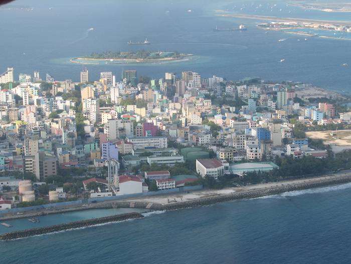
Malé, is the capital and most populous city in the Republic of Maldives. It is located at the southern edge of North Malé Atoll (Kaafu Atoll). It is also one of the Administrative divisions of the Maldives. Traditionally it was the King's Island, from where the ancient Maldive Royal dynasties ruled and where the palace was located. The city was also called Mahal. Formerly it was a walled city surrounded by fortifications and gates (doroshi). The Royal Palace (Gan'duvaru) was destroyed along with the picturesque forts (kotte) and bastions (buruzu) when the city was remodelled under President Ibrahim Nasir's rule after the abolition of the monarchy. However, the beautifully decorated Male' Hukuru Miskiy remains. In recent years, the island has been considerably expanded through landfilling operations. Over the years there have been many coup attempts and protests centered in Male as a result of demand for greater democracy in the Maldives.
Male, is the capital and most populous city in the Republic of Maldives. It is located at the southern edge of North Malé Atoll (Kaafu Atoll). It is also one of the Administrative divisions of the Maldives. Traditionally it was the King's Island, from where the ancient Maldive Royal dynasties ruled and where the palace was located. The city was also called Mahal.
Photo — Link

The whole island group, the Maldives, is named after its capital. The word "Maldives" means "The islands (dives) of Male'". The first settlers in the Maldive islands were Dravidian people from the nearest shores, which are in the modern Indian Subcontinent and coastal Ceylon. Comparative studies of Maldivian linguistic, oral and other cultural traditions, in addition to folklore, point to a strong Dravidian influence on Maldivian society, centered in Malé, from ancient times. The people of Giraavaru, an island located in Malé Atoll (now a tourist resort, after the forced diaspora of its inhabitants) claim to descend from the first settlers of the Maldives, ancient Tamils. 19 more images after the break...

Male, is the capital and most populous city in the Republic of Maldives. It is located at the southern edge of North Malé Atoll (Kaafu Atoll). It is also one of the Administrative divisions of the Maldives. Traditionally it was the King's Island, from where the ancient Maldive Royal dynasties ruled and where the palace was located. The city was also called Mahal.
Photo — Link

It is said that Giraavaru fishermen used to go regularly to a certain large sandbank (finolhu) at the southern end of their atoll to clean tuna fish after a good catch. Owing to the large amount of tuna fish offal and blood, the waters around that sandbank looked like a big pool of blood (maa ley gandeh). "Maa" (from the Sanskrit  "Maha"), meaning big, and "Le" meaning blood. Traditionally the first inhabitants of the Maldives, which include the Giravaru people, didn't have kings. They lived in a simple society and were ruled by local headmen. But one day a prince from the Subcontinent called Koimala arrived to Malé Atoll sailing from the North on a big ship. The people of Giraavaru spotted his vessel from afar and welcomed him. They allowed Prince Koimala to settle on that large sandbank in the midst of the waters tainted with fish blood. Trees were planted on the sandbank and it is said that the first tree that grew on it was the papaya tree. However this could refer to any tree that bears edible fruit as the archaic Dhivehi word (and Mahal word even today) for fruit was the same as that for the papaya (falhoa). As time went by the local islanders accepted the rule of this Northern Prince. A palace was built and the island was formally named Maa-le (Malé), while the nearest island was named Hulhu-le.

Male, is the capital and most populous city in the Republic of Maldives. It is located at the southern edge of North Malé Atoll (Kaafu Atoll). It is also one of the Administrative divisions of the Maldives. Traditionally it was the King's Island, from where the ancient Maldive Royal dynasties ruled and where the palace was located. The city was also called Mahal.
Photo — Link

The names of the main four wards or divisions of Malé Island are said to have been given by the aboriginal Giraavaru fishermen: Maafannu from "maa" (big) and "fannu" (a place where a village path meets the sea), Henveiru from "en-beyru" (out where fishermen got their bait), Galolhu from "galu-olhu" (stone groove) and, Macchangolhi from "mathi-angolhi" (windward path-fork). The modern-day city was founded as a trading post by the Portuguese in the 16th century.

Male, is the capital and most populous city in the Republic of Maldives. It is located at the southern edge of North Malé Atoll (Kaafu Atoll). It is also one of the Administrative divisions of the Maldives. Traditionally it was the King's Island, from where the ancient Maldive Royal dynasties ruled and where the palace was located. The city was also called Mahal.
Photo — Link

Aqueduct of Segovia

Aqueduct of Segovia

The Aqueduct of Segovia is a Roman aqueduct and one of the most significant and best-preserved ancient monuments left on the Iberian Peninsula. It is located in Spain and is the foremost symbol of Segovia, as evidenced by its presence on the city's coat of arms.
History — As the aqueduct lacks a legible inscription (one was apparently located in the structure's attic, or top portion), the date of construction cannot be definitively determined. Researchers have placed it between the second half of the 1st Century AD and the early years of the 2nd Century—during the reign of either Emperor Vespasian or Nerva. The beginnings of Segovia itself are likewise not definitively known. The people called Vaccaei are known to have populated the place or area before the Romans conquered the city. Roman troops sent to control the area stayed behind to settle there. The area fell within the jurisdiction of the Roman provincial court (Latin conventus iuridici, Spanish convento jurídico) located in Clunia.
The Aqueduct of Segovia is a Roman aqueduct and one of the most significant and best-preserved ancient monuments left on the Iberian Peninsula. It is located in Spain and is the foremost symbol of Segovia, as evidenced by its presence on the city's coat of arms.
Photo — Link
Description — The aqueduct transports waters from Fuente Fría river, situated in the nearby mountains, some 17 km (11 mi) from the city in a region known as La Acebeda. It runs another 15 km (9.3 mi) before arriving in the city.
The water is first gathered in a tank known as El Caserón (or Big House), and is then led through a channel to a second tower known as the Casa de Aguas (or Waterhouse). There it is naturally decanted and sand settles out before the water continues its route. Next the water travels 728 m (796 yd) on a one-percent grade until it is high upon the Postigo, a rocky outcropping on which the old city center, the Segovia Alcázar, was built. Then, at Plaza de Díaz Sanz (Díaz Sanz Square), the structure makes an abrupt turn and heads toward Plaza Azoguejo (Azoguejo Square). It is there the monument begins to display its full splendor. At its tallest, the aqueduct reaches a height of 28.5 m (93 ft 6 in), including nearly 6 m (19 ft 8 in) of foundation. There are both single and double arches supported by pillars. From the point the aqueduct enters the city until it reaches Plaza de Díaz Sanz, it includes 75 single arches and 44 double arches (or 88 arches when counted individually), followed by four single arches, totalling 166 arches in all. 14 more images after the break...

The Aqueduct of Segovia is a Roman aqueduct and one of the most significant and best-preserved ancient monuments left on the Iberian Peninsula. It is located in Spain and is the foremost symbol of Segovia, as evidenced by its presence on the city's coat of arms.
Photo — Link


The construction of the aqueduct follows the principles laid out by Vitruvius as he describes in his De Architectura published in the mid-first century.
Construction — The first section of the aqueduct contains 36 semi-circular arches, rebuilt in the 15th century to restore a portion destroyed by the Moors in 1072. The line of arches is organized in two levels, decorated simply, in which predominantly simple moulds hold the frame and provide support to the structure. On the upper level, the arches have a total width of 5.1 meters (16.1 ft). Built in two levels, the top pillars are both shorter and narrower than those on the lower level. The top of the structure contains the channel through which water travels, through a U-shaped hollow measuring 0.55 by 0.46 in circumference size. The top of each pillar has a cross-section measuring 1.8 by 2.5 meters (5.9 by 8.2 feet), while the base cross-section measures approximately 2.4 by 3 meters (7.9 by 9.8 feet).
Principal facade of the Aqueduct of Segovia. The aqueduct is built of unmortared, brick-like granite blocks. During the Roman era, each of the three tallest arches displayed a sign in bronze letters, indicating the name of its builder along with the date of construction. Today, two niches are still visible, one on each side of the aqueduct. One of them is known to have held the image of Hercules, who according to legend was founder of the city. The other niche now contains the images of the Virgen de la Fuencisla (the Patroness of Segovia) and Saint Stephen.

The Aqueduct of Segovia is a Roman aqueduct and one of the most significant and best-preserved ancient monuments left on the Iberian Peninsula. It is located in Spain and is the foremost symbol of Segovia, as evidenced by its presence on the city's coat of arms.Photo — Link

The Aqueduct of Segovia is a Roman aqueduct and one of the most significant and best-preserved ancient monuments left on the Iberian Peninsula. It is located in Spain and is the foremost symbol of Segovia, as evidenced by its presence on the city's coat of arms.
Photo — Link

The Aqueduct of Segovia is a Roman aqueduct and one of the most significant and best-preserved ancient monuments left on the Iberian Peninsula. It is located in Spain and is the foremost symbol of Segovia, as evidenced by its presence on the city's coat of arms.
Photo — Link

The Aqueduct of Segovia is a Roman aqueduct and one of the most significant and best-preserved ancient monuments left on the Iberian Peninsula. It is located in Spain and is the foremost symbol of Segovia, as evidenced by its presence on the city's coat of arms.
Photo — Link

The Aqueduct of Segovia is a Roman aqueduct and one of the most significant and best-preserved ancient monuments left on the Iberian Peninsula. It is located in Spain and is the foremost symbol of Segovia, as evidenced by its presence on the city's coat of arms.
Photo — Link

The Aqueduct of Segovia is a Roman aqueduct and one of the most significant and best-preserved ancient monuments left on the Iberian Peninsula. It is located in Spain and is the foremost symbol of Segovia, as evidenced by its presence on the city's coat of arms.
Photo — Link

The Aqueduct of Segovia is a Roman aqueduct and one of the most significant and best-preserved ancient monuments left on the Iberian Peninsula. It is located in Spain and is the foremost symbol of Segovia, as evidenced by its presence on the city's coat of arms.
Photo — Link

The Aqueduct of Segovia is a Roman aqueduct and one of the most significant and best-preserved ancient monuments left on the Iberian Peninsula. It is located in Spain and is the foremost symbol of Segovia, as evidenced by its presence on the city's coat of arms.
Photo — Link

The Aqueduct of Segovia is a Roman aqueduct and one of the most significant and best-preserved ancient monuments left on the Iberian Peninsula. It is located in Spain and is the foremost symbol of Segovia, as evidenced by its presence on the city's coat of arms.
Photo — Link

The Aqueduct of Segovia is a Roman aqueduct and one of the most significant and best-preserved ancient monuments left on the Iberian Peninsula. It is located in Spain and is the foremost symbol of Segovia, as evidenced by its presence on the city's coat of arms.
Photo — Link

The Aqueduct of Segovia is a Roman aqueduct and one of the most significant and best-preserved ancient monuments left on the Iberian Peninsula. It is located in Spain and is the foremost symbol of Segovia, as evidenced by its presence on the city's coat of arms.
Photo — Link

The Aqueduct of Segovia is a Roman aqueduct and one of the most significant and best-preserved ancient monuments left on the Iberian Peninsula. It is located in Spain and is the foremost symbol of Segovia, as evidenced by its presence on the city's coat of arms.
Photo — Link
The Aqueduct of Segovia is a Roman aqueduct and one of the most significant and best-preserved ancient monuments left on the Iberian Peninsula. It is located in Spain and is the foremost symbol of Segovia, as evidenced by its presence on the city's coat of arms.

Aerial Shots of International Airports by Jeffrey Milstein

Aerial Shots of International Airports by Jeffrey Milstein

Jeffrey Milstein Aerial Shots of  International Airport, The series displays "the patterns, layering and complexity of cities, and the circulation patterns for travel, such as waterways, roads, and airports that grow organically over time much like a living organism." The interweaving roads and geometric presentation viewed in the collection is a unique sight to be seen from a bird's-eye view. While exhilarating to be moving in midair, the images exhibit the beautiful downtime and landing marks for airplanes.

Inspired by a childhood spent filming planes at LAX with an 8-millimeter videocamera, New York photographer and former Berkeley architecture student Jeffrey Milstein has turned his fascination for aviation into a career. Typically known for photographing the underbellies of aircrafts, Milstein’s latest series captures the artistic composition and elaborate array of patterns formed by airports and only seen from above. He describes this series as revealing “the patterns, layering and complexity of cities, and the circulation patterns for travel, such as waterways, roads, and airports that grow organically over time much like a living organism.” 09 more images after the break...

Jeffrey Milstein Aerial Shots of  International Airport, The series displays "the patterns, layering and complexity of cities, and the circulation patterns for travel, such as waterways, roads, and airports that grow organically over time much like a living organism." The interweaving roads and geometric presentation viewed in the collection is a unique sight to be seen from a bird's-eye view. While exhilarating to be moving in midair, the images exhibit the beautiful downtime and landing marks for airplanes.

Jeffrey Milstein Aerial Shots of  International Airport, The series displays "the patterns, layering and complexity of cities, and the circulation patterns for travel, such as waterways, roads, and airports that grow organically over time much like a living organism." The interweaving roads and geometric presentation viewed in the collection is a unique sight to be seen from a bird's-eye view. While exhilarating to be moving in midair, the images exhibit the beautiful downtime and landing marks for airplanes.

Jeffrey Milstein Aerial Shots of  International Airport, The series displays "the patterns, layering and complexity of cities, and the circulation patterns for travel, such as waterways, roads, and airports that grow organically over time much like a living organism." The interweaving roads and geometric presentation viewed in the collection is a unique sight to be seen from a bird's-eye view. While exhilarating to be moving in midair, the images exhibit the beautiful downtime and landing marks for airplanes.

Jeffrey Milstein Aerial Shots of  International Airport, The series displays "the patterns, layering and complexity of cities, and the circulation patterns for travel, such as waterways, roads, and airports that grow organically over time much like a living organism." The interweaving roads and geometric presentation viewed in the collection is a unique sight to be seen from a bird's-eye view. While exhilarating to be moving in midair, the images exhibit the beautiful downtime and landing marks for airplanes.

Jeffrey Milstein Aerial Shots of  International Airport, The series displays "the patterns, layering and complexity of cities, and the circulation patterns for travel, such as waterways, roads, and airports that grow organically over time much like a living organism." The interweaving roads and geometric presentation viewed in the collection is a unique sight to be seen from a bird's-eye view. While exhilarating to be moving in midair, the images exhibit the beautiful downtime and landing marks for airplanes.

Jeffrey Milstein Aerial Shots of  International Airport, The series displays "the patterns, layering and complexity of cities, and the circulation patterns for travel, such as waterways, roads, and airports that grow organically over time much like a living organism." The interweaving roads and geometric presentation viewed in the collection is a unique sight to be seen from a bird's-eye view. While exhilarating to be moving in midair, the images exhibit the beautiful downtime and landing marks for airplanes.

Jeffrey Milstein Aerial Shots of  International Airport, The series displays "the patterns, layering and complexity of cities, and the circulation patterns for travel, such as waterways, roads, and airports that grow organically over time much like a living organism." The interweaving roads and geometric presentation viewed in the collection is a unique sight to be seen from a bird's-eye view. While exhilarating to be moving in midair, the images exhibit the beautiful downtime and landing marks for airplanes.

Jeffrey Milstein Aerial Shots of  International Airport, The series displays "the patterns, layering and complexity of cities, and the circulation patterns for travel, such as waterways, roads, and airports that grow organically over time much like a living organism." The interweaving roads and geometric presentation viewed in the collection is a unique sight to be seen from a bird's-eye view. While exhilarating to be moving in midair, the images exhibit the beautiful downtime and landing marks for airplanes.

Jeffrey Milstein Aerial Shots of  International Airport, The series displays "the patterns, layering and complexity of cities, and the circulation patterns for travel, such as waterways, roads, and airports that grow organically over time much like a living organism." The interweaving roads and geometric presentation viewed in the collection is a unique sight to be seen from a bird's-eye view. While exhilarating to be moving in midair, the images exhibit the beautiful downtime and landing marks for airplanes.